It's not JUST about what I had for breakfast...

Sunday, January 31, 2016

Saturday In Lopez Canyon

This is from last week.  Did I post is then?  If so, why was it still in the folder?  Looks to be in Lopez Canyon, so at least it's the same place I went to today.


I went out this morning to get some more of those caches in and around Lopez Canyon.  I found all of them EXCEPT the farthest one up the valley.  As soon as I posted my DNF (Did Not Find) log the cache owner archived it. So I'll never find out where it was...

One of the caches had a very lifelike lizard on it...


Too bad the photo is so crummy.  Sometimes the phone camera doesn't focus, probably 'cause I'm holding it too close to the subject.

A panorama showing way too much foreground, but also I-5, a bit of Sorrento Valley, and the Penasquitos Canyon area.Taken from a hill


Not too far away are the remains of the Lopez homestead, that this valley is named for.


I thought I was seeing the return of the USS Akron, but it turned out to be a blimp over some golf tournament or something. The Goodyear "blimp" people say they are at the Farmers, but the airship below does not seem to have the Goodyear colors on it.


It is a mystery.

I found nineteen geocaches today, and boy, are my feet tired!

Thanks for reading!

Sunday, January 24, 2016

Sunday Out and About

Found this totally soaked cache. No wonder, what with the broken lid!  The new log sheet from a previous finder, replaced because the previous one was wet, is also ruined.


This one was easy to find.  And the previous three searchers didn't spot it.  This is about twenty feet and a little hillside from where it's SUPPOSED to be, though.

Sorry, I didn't make a thumbnail for this one


Lopez Canyon.  Rocks, it's all rocks!


Is this poison oak, in one of its many varieties?  I couldn't decide it WAS, but I couldn't decide it was NOT.


Can you spot the cache?  I spent an hour here...


Closer...


Aahhh, there it is!


As I was heading back to the sidetrail that would take me up to the road where I parked I met a couple who asked me if the falls were close by.  I told them they were in the wrong canyon.  They should have taken a left at the trail junction and gone UNDER the bridge.  They were quite dismayed.  It just occurred to me, did they not notice there is no running water in this canyon?

I found fifteen caches today.  Mostly driving from cache to cache, with a bit of walking, then one longer descent into the canyon and back out again.  Got the ol' ticker pounding a bit!

Thanks for reading!

Saturday, January 23, 2016

Out And About On Saturday

It is raining right now, but it was a pretty nice day when I was clomping about the Upper Otay Lake area this morning.  Mostly hazy/overcast, some sun, one giant burst of wind that made me step back from the tree I was examining, just in case it decided to shed itself of some branches.

I decided it was just about the same distance to drive via Jamul as to go down the 125, so I did that, catching Proctor Valley Road there.  I four caches along the way, three of which I had DNFed (Did Not Find) in 2014.  As it turned out I did not notice the first catch on the list so I went back to get it on the return home.  Driving along the PVR (I just made that up) is a lot of fun, especially if you drive fast enough to slide around as the washboard surface tosses you up into the air a bit...

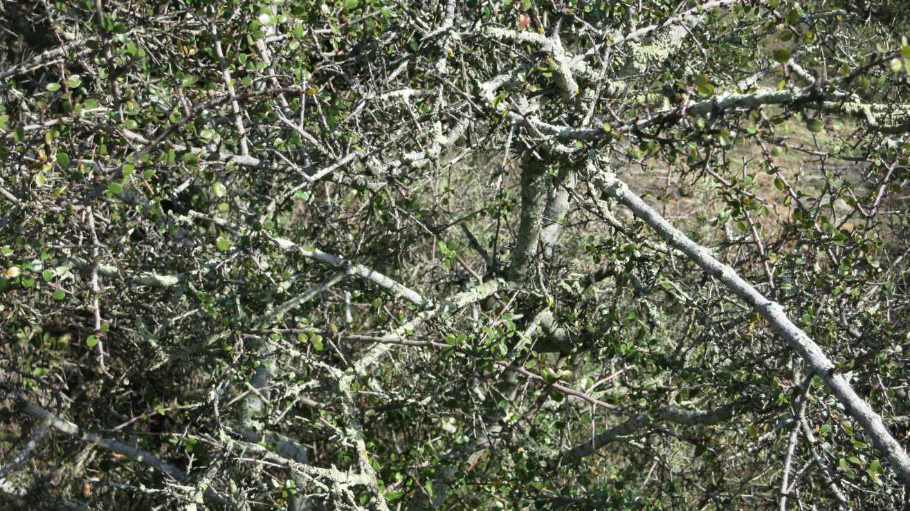
Here is a picture of one of the caches.  I spent a LOT of time looking for it, and even looked here twice before I spotted it. Can YOU see it?  A pen for size comparison.


On to Upper Otay Lake!  I parked and walked in outside as the Lake is closed to vehicles today. I circled the lake clockwise.  There are lots of signs warning people to stay away from the dam and spillway area.

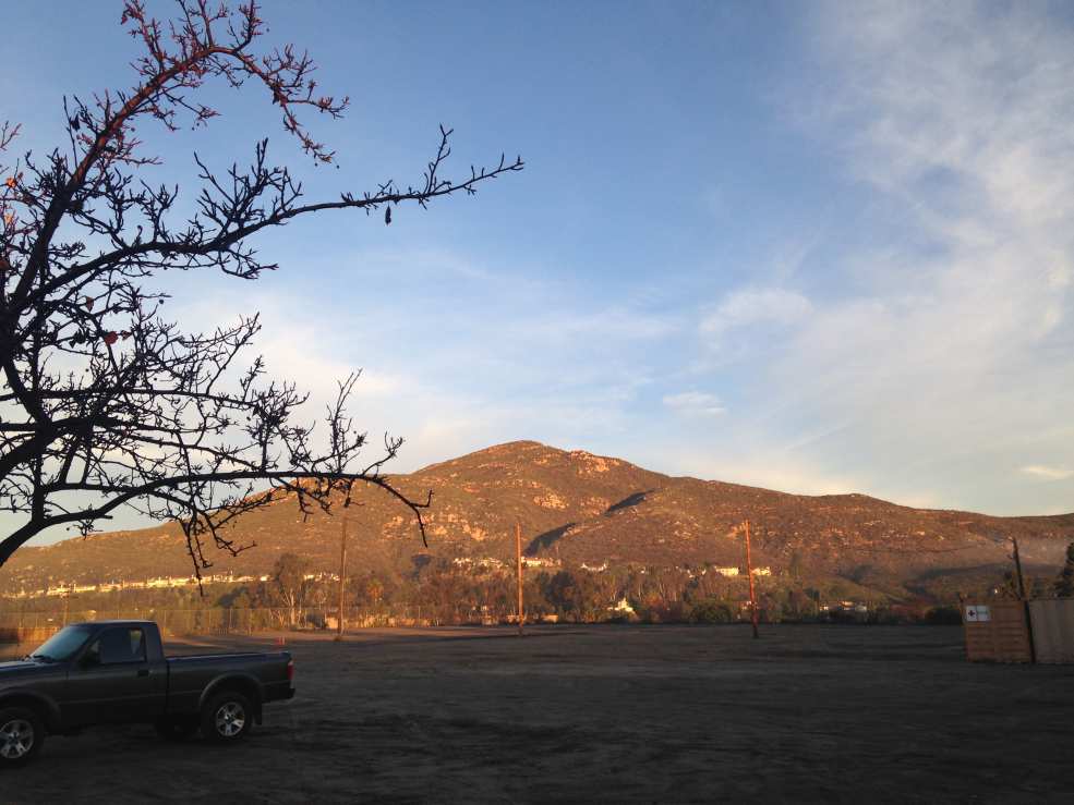
Here one view of the dam, from the west side.  There are so many plants you can't see the water level!


I found these glasses in one cache, but I didn't bring anything to trade for them, so back they go.


 Yet again I had nothing to trade for something that was nifty in a cache!


I think this panorama picture turned out really nice.  I took it on a sort of peninsula.  I walked out to the south end, then had to walk all the way back as there was no real way to get to the trail that heads south.


Walked on a bit farther down "Wueste Road", which is actually a narrow trail, at least along here.  A nice view of the Upper dam and lake, and beyond you can see the Lower Otay lake.


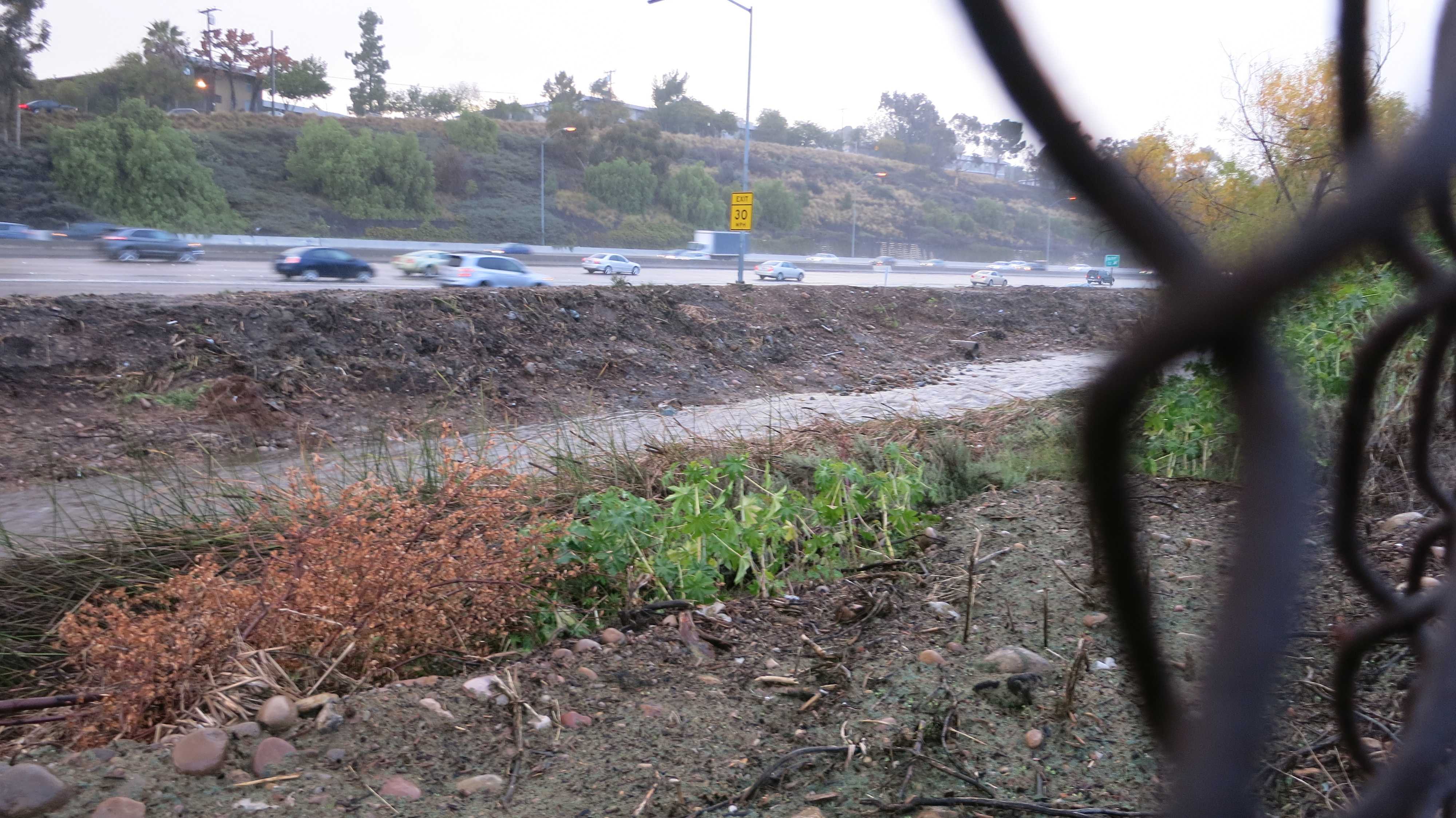
Here is the dam from the east side.  It makes a nice surface for budding artists to practice on.


After finishing up at the lake I drove around to the other end where there was a walking trail along the rim of the valley, right below all the new "gated" houses (Mansions, really, what with the individual gates) being built.  Very nice views of the lake below.


I found one cache on the walking trail, and didn't find two.  Then I drove back along the PVR to get that cached I missed at the beginning of the day, found it, and headed home.

I found nineteen caches today, and DNFed  two.  I walked pretty darn close to five miles.  I reached my goal for last year of having found 4,000 caches in my "career".  I'm figuring that I might even hit 5,000 finds early in 2017, and I might reward myself with one of them fancy commemorative medallions they sell at the geocaching stores.

Thanks for reading!

Thursday, January 21, 2016

Gotta Get To Bed, So HERE!

On the way to work this morning I just HAD to take some pics.  I actually rolled down the window for this first one.


This must be along Fletcher Parkway. I did not roll down the windshield for this one!


This was a little bit further along Fletcher Parkway.  I decided to turn left and make my way to Lake Murray.


So here is Baltimore Drive at Lake Murray.  Not the Blvd., the lake!


It didn't take too long for the fog to burn off. There wasn't very much fog on Cowles Moutain anyway. I took this pic around 8 AM or so.


Someone mentioned they wanted to borrow a few barcode scanners because they only had old ones with PS2 connectors.  I replied with this pic, saying my old wand works just fine (Like I ever use it since I have a laser barcode reader! Wrist injury!)  And they replied back that I would get cooties from that old thing.


I made an appointment for the CT-Scan today, for a couple of weeks from now.

Bought another squeegee as I keep leaving them at gas stations.

Thanks for reading!

Wednesday, January 20, 2016

Saturday the 16th

Since I solved a puzzle cache (at work!) I called M. and we went for it and others on Saturday in and about Lopez Canyon. a place that was new to me.

It's a typical "sewer" canyon, that is there is a sewer line running through it, like many do.  A lot of water has been running through it, too, you can see the sides of the canyon that have collapsed, giant plants with enormous roots balls exposed.  The bottom of the canyon is almost all rocks maybe six inches in diameter, very tiring to walk on, real ankles twisters.

On exiting the canyon I went for this one way up high, with a great view.  M. declined to make the somewhat perilous climb and stayed below to guard my backpack.  I kinda wanted to lower a center of gravity a bit here...


Here is a pic of M. down there taking a pic of me up here!


I think we found around twelve caches total on this little walk.  One was full of mold, one had amazing things in it, one was a "doggie" cache, one was the mystery cache, and there was this one way up thar, so quite a number of memorial caches here.

Sunday I did absolutely nothing.

Monday I went to the dentist and the doctor.

Wednesday I went to the other doctor.  Nothing to report, everything seems OK at this point.

Thanks for reading!

Sunday, January 10, 2016

Another Dumb Weekend Spent Doing Practically Nothing

Some of these pics, you may have seen them on FB.

This is from Monday, a face full of Novocaine.  It was really saggy on one side when I left the dentist, so this is a LOT better!  It was looking like I had a stroke or something!


We got a little rain this last week.  One morning it occurred to me to go down to check out if Alvarado Creek was flooding.  Nope, it is not.


Too bad I didn't get a picture when the deluge happened earlier!


The city has done a lot of maintenance on the creek bed, removing various plants that do not belong there.


But maybe they are not quite finished?


There used to be a big red "T" on Lake Murray Blvd. but it is long gone.  This one is in the La Presa/Spring Valley area.  The image is from Google Streetview.


I did not leave the abode all weekend until Sunday afternoon.  I was moved to replace a log sheet on one of my caches, so I thought I better find a couple, too.  I did the cache maintenance on the cache, which was located off of Fanita in Santee/El Cajon, then I headed over to Tierrasanta. 

Here's the view from a new cache out there, showing a possible alien (from space!) mining operation.


I thought (not too clearly) that I'd go down this road, DOWN into the valley, to get five or six caches.  Well, I got one on the down hill, another at the bottom, then I went up that road to the top of the rise there, then I thought better of the whole enterprise.  Since I didn't bring a flashlight, perhaps I had better come back another day.  So I trudge UP the very steep hill, back to this spot, then back to the vehicle, and home again.


Oh joy, the weekend is finished.

Sunday, January 03, 2016

Last Day Sunday

Well, it is the last day of vacation, and back to work tomorrow.  For a couple of hours, anyway, then it's off to the dentist for a bunch of work, then it's home to recover.

Sunday morning I got up before dawn and headed out.

The first cache I had planned (and yes, I did actually plan this trip!) was at the Big Red T in "Spring Valley" (Not really Spring Valley, I see).  Don't remember those?  They were Thriftimart grocery stores. There used to be one on Lake Murray Blvd. in the "San Carlos" area, as we called it.  I took a helpful tool along and was able to find the cache this time, on my third visit there.

This image is from Google Street View.

I then drove down to a residential area near to the Sleep Train Amphitheater (Is that the correct name this week?) and hiked the hills looking for three caches.  Several VERY steep hills involved, and found the caches.  Saw one dog in a yard who did not bark, but "woofed" very determinedly. 

Due to the un-connectivity of the roads I had to drive about four miles to get to the other side of the canyon to get two more caches.  These were the last of the "Spooky Canyon" cache series.

Here we got a panorama looking to the west, to start.  It's a really big file so you can zoom in a bit. You can see ships in the ocean!

File size:  881 KB

This one is to show where the truck is parked, way way down there!  And how far I had to ascend to get this view!

File size:  638 KB

No more pictures, but after getting safely down the treacherous hill I drove even farther south to the Otay Mesa area to find eleven or so assorted caches. There were not any hill to climb, but some of them were a bit tricky, and sometimes parking was difficult to come by.

Lastly, I headed home but got off at Bonita Road 'cause I had a idea I want to have an even twenty caches found for the day.  So I kept looking for easy caches to find, and kept getting thwarted by one thing or another.  I finally parked at Sweetwater Regional Park and walked a thousand feet to a cache, found it, then decided I didn't really NEED to find twenty caches today, and drove home.

Well, not quite home, I went to El Pollo Loco and got a Ultimate Double Chicken Enchiladas, which I see has WAY too many carbs, I should have chosen a regular Chicken Enchiladas and skipped the rice.  Anyway, I've been hankering for this and finally, after several weeks, got it.  It was OK, I should probably get enchiladas at a regular taco shop for comparison purposes.

Thanks for reading!

Saturday, January 02, 2016

A Link To Where Today's Content Is...

I rode the bike for a while today, so all of the content is over on the bike blog

Search This Blog

About Me

Blog Archive

Followers